SPM Features
SPM provides a powerful and dynamic scenario creation, modeling, and data organization framework designed to facilitate more informed and collaborative planning by providing a comprehensive view of potential futures. Its suite of tools and analytic engines enable the creation and organization of local and regional data, plans and policies, facilitate scenario creation and editing, and estimate a wide range of potential benefits resulting from alternative transportation and land use strategies.
Data Development and Organization
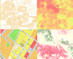
Scenario-based planning with SPM starts with a detailed baseline assessment of the existing conditions or base “canvas” at the Scenario Planning Zone (SPZ) level. The SPZs are the minimum unit of scenario planning and analysis that SCAG developed by grouping parcels of uniform or compatible land uses while maintaining manageable size for capturing local land use benefits on transportation, varied by development density and intensity.
SPM streamlines the development of the base canvas through scripts and processes that normalize data of varying quality, type and scale from a wide range of sources, including land cover and environmental data, demographic characteristics, roadway and transit that provide the foundation for analysis by SPM’s various analysis engines.
Scenario Development
The base canvas provides the context for scenario painting and editing, and subsequent analysis. Once the base canvas is set, scenarios can be created in two ways: translation of existing plans, and ‘painting’ or editing of new or existing plans or scenarios.
Existing Plan Translation
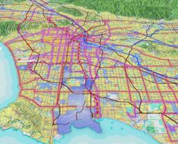
SPM analyzes existing plans or scenarios at any scale based on their key characteristics such as density, mix of uses, and street connectivity. It then translates each geographic area (e.g., parcel, TAZ, or SPZ) of the input plan into one of the model’s common language of Place Types and Building Types. Place Types represent a full range of potential development types and patterns, from urban mixed-use centers, to employment and industrial areas, to standard suburban residential areas that can be seen across the SCAG region. Each Place Type is composed of a mix of different building types and represents a unique set of assumptions that facilitate scenario modeling and testing at a variety of scales. This allows SCAG to integrate local plans together into a common regional fabric of land use and transportation plan and to perform consistent analysis on individual plans or combinations thereof.
Scenario Painting and Editing
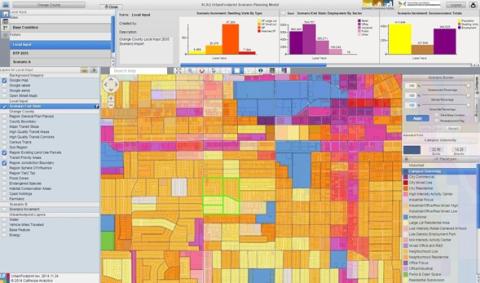
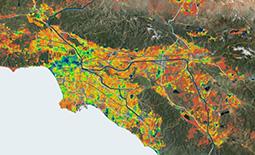
SPM’s web-based scenario painter, that includes a suite of selection and viewing tools, allows the user to edit or build upon a translated plan or scenario, or create new scenarios from scratch by applying Place Types to the landscape (see Figure below). In addition to various spatial data layers available via SPM’s graphical user interface, ranging from parcel level land use, to statewide resource areas and farmland, the web- based scenario painter can also display regularly updated data available on the web today (e.g., Google Maps, Open Street Map). SPM builds a scenario by adding the “change” or “increment” that you’ve painted on top of a base condition. The combination of the two produces what is known as the “End state” which represents what will be on the ground in the future.
Scenario Analysis
SPM analysis modules produce a wide range of inter-related metrics that allow for robust and meaningful comparisons of alternative land use and transportation scenarios. Once changes are made to the base canvas via painting or translation of existing plan, scenario core processes combine the changes or growth input with the existing conditions to create future scenarios and estimate developable land and demographic characteristics.
These scenarios then run through the model engines briefly described below to measure their performance for mobility, air quality, public health, fiscal impacts, resource consumptions, and others.
Land Consumption Engine
Land Consumption engine calculates greenfield land consumed to accommodate new growth for future scenarios. Greenfield is identified based on the assessment of the base year or existing condition. Total land consumed in the existing greenfield is then estimated by applying per unit or per employee assumptions, accounting for housing type as well as employment sector.
Fiscal Impact Engine
Fiscal Impact Engine estimates the impacts of varying forms of development on local expenditures. The current engine limits its focus to the impacts associated with new residential growth, accounting for the capital costs of new and upgraded local infrastructure, and operations and maintenance (O&M) costs to serve new and upgraded infrastructures. Cost factors vary by Land Development Category (LDC), development condition (refill or greenfield), and housing type (single family detached large lot, single family detached small lot, single family attached or multifamily).
Building Energy Engine
Building Energy Engine calculates residential and commercial building energy use, and their related costs and greenhouse gas (GHG) emissions, for both new and existing buildings. Within the engine, energy use is determined by three types of variables: building characteristics, climate zone, and efficiency factors. Building characteristics and climate zone determine what baseline per-residential unit or per-commercial square foot factors are used to calculate energy use. Reductions are then applied to the resulting baseline estimates to reflect the implementation of building efficiency and conservation policies into the future.
Water Engine
Water Engine calculates indoor and outdoor residential and commercial water use, and their related costs and greenhouse gas (GHG) emissions, for both new and existing buildings. Indoor and outdoor water use is first calculated according to baseline rates, determined by building or employment characteristics and climate zone, and then adjusted to account for the application of efficiency and conservation policies into the future.
Transportation Engine
SPM incorporates a comprehensive “sketch” travel model that produces vehicle miles traveled (VMT), mode choice, and congestion estimates for land use and transportation scenarios, as well as transportation-related costs, greenhouse gas (GHG) emissions, and pollutant emissions. Transportation analysis capabilities within SPM are currently based on the Mixed-Use Development (MXD) trip generation model that estimates the likely degree to which a development area’s traffic generation will be reduced due to trip internalization, external walking, or transit trips. The MXD method uses land use and demographic information as well as outputs from regional transportation model to calculate trip reductions, resulting from the specific combination of factors known to be most influential in trip generation.
Public Health Engine
Public health engine measures the impact of land use patterns and urban form on physical activity-related weight and disease incidences, and respiratory impacts, as well as their related costs. Respiratory health analysis is based on overall VMT from SCAG’s regional transportation model and associated criteria air pollutant emissions from EMFAC. Health incidence and valuation assumptions for select air pollutants (PM2.5, Sox, VOC and NOx) are then applied to estimate pollution-related health incidences and costs.
Physical-activity related health incidences are calculated from California Public Health Assessment Model (C-PHAM) that uses a behavioral and exposure-based pathway approach that links the built environment with health outcomes. C-PHAM provided health outcomes include the Body Mass Index (BMI), the likelihood of being obese or having high blood pressure/heart disease/type 2 diabetes by age group.

Land Conservation Engine
SPM incorporates the Nature Conservancy’s land conservation engine that measures the impacts of change upon a detailed depiction of existing conditions on the four major themes: carbon, water, agriculture, and habitat. The terrestrial carbon storage model analyzes the impact of land use changes on carbon storage associated with natural vegetation in the landscape as well as with soil organic carbon. The water theme measures the impacts of changes to natural lands or land cover on watershed, the ground recharge potential of converted lands, water resource priority areas, and agricultural land with associated water demand. The terrestrial habitat model measures the capacity of the landscape to facilitate or inhibit species movement and the suitability of land use in an area to support terrestrial vertebrates. The agricultural model estimates the impact of land conversion on agricultural production and capacity.
Data Development and Organization
Scenario-based planning with SPM starts with a detailed baseline assessment of the existing conditions or base “canvas” at the Scenario Planning Zone (SPZ) level. The SPZs are the minimum unit of scenario planning and analysis that SCAG developed by grouping parcels of uniform or compatible land uses while maintaining manageable size for capturing local land use benefits on transportation, varied by development density and intensity.
SPM streamlines the development of the base canvas through scripts and processes that normalize data of varying quality, type and scale from a wide range of sources, including land cover and environmental data, demographic characteristics, roadway and transit that provide the foundation for analysis by SPM’s various analysis engines.
Scenario Development
The base canvas provides the context for scenario painting and editing, and subsequent analysis. Once the base canvas is set, scenarios can be created in two ways: translation of existing plans, and ‘painting’ or editing of new or existing plans or scenarios.
Existing Plan Translation
SPM analyzes existing plans or scenarios at any scale based on their key characteristics such as density, mix of uses, and street connectivity. It then translates each geographic area (e.g., parcel, TAZ, or SPZ) of the input plan into one of the model’s common language of Place Types and Building Types. Place Types represent a full range of potential development types and patterns, from urban mixed-use centers, to employment and industrial areas, to standard suburban residential areas that can be seen across the SCAG region. Each Place Type is composed of a mix of different building types and represents a unique set of assumptions that facilitate scenario modeling and testing at a variety of scales. This allows SCAG to integrate local plans together into a common regional fabric of land use and transportation plan and to perform consistent analysis on individual plans or combinations thereof.
Scenario Painting and Editing
SPM’s web-based scenario painter, that includes a suite of selection and viewing tools, allows the user to edit or build upon a translated plan or scenario, or create new scenarios from scratch by applying Place Types to the landscape (see Figure below). In addition to various spatial data layers available via SPM’s graphical user interface, ranging from parcel level land use, to statewide resource areas and farmland, the web- based scenario painter can also display regularly updated data available on the web today (e.g., Google Maps, Open Street Map). SPM builds a scenario by adding the “change” or “increment” that you’ve painted on top of a base condition. The combination of the two produces what is known as the “End state” which represents what will be on the ground in the future.
Scenario Analysis
SPM analysis modules produce a wide range of inter-related metrics that allow for robust and meaningful comparisons of alternative land use and transportation scenarios. Once changes are made to the base canvas via painting or translation of existing plan, scenario core processes combine the changes or growth input with the existing conditions to create future scenarios and estimate developable land and demographic characteristics.
These scenarios then run through the model engines briefly described below to measure their performance for mobility, air quality, public health, fiscal impacts, resource consumptions, and others.
Land Consumption Engine
Land Consumption engine calculates greenfield land consumed to accommodate new growth for future scenarios. Greenfield is identified based on the assessment of the base year or existing condition. Total land consumed in the existing greenfield is then estimated by applying per unit or per employee assumptions, accounting for housing type as well as employment sector.
Fiscal Impact Engine
Fiscal Impact Engine estimates the impacts of varying forms of development on local expenditures. The current engine limits its focus to the impacts associated with new residential growth, accounting for the capital costs of new and upgraded local infrastructure, and operations and maintenance (O&M) costs to serve new and upgraded infrastructures. Cost factors vary by Land Development Category (LDC), development condition (refill or greenfield), and housing type (single family detached large lot, single family detached small lot, single family attached or multifamily).
Building Energy Engine
Building Energy Engine calculates residential and commercial building energy use, and their related costs and greenhouse gas (GHG) emissions, for both new and existing buildings. Within the engine, energy use is determined by three types of variables: building characteristics, climate zone, and efficiency factors. Building characteristics and climate zone determine what baseline per-residential unit or per-commercial square foot factors are used to calculate energy use. Reductions are then applied to the resulting baseline estimates to reflect the implementation of building efficiency and conservation policies into the future.
Water Engine
Water Engine calculates indoor and outdoor residential and commercial water use, and their related costs and greenhouse gas (GHG) emissions, for both new and existing buildings. Indoor and outdoor water use is first calculated according to baseline rates, determined by building or employment characteristics and climate zone, and then adjusted to account for the application of efficiency and conservation policies into the future.
Transportation Engine
SPM incorporates a comprehensive “sketch” travel model that produces vehicle miles traveled (VMT), mode choice, and congestion estimates for land use and transportation scenarios, as well as transportation-related costs, greenhouse gas (GHG) emissions, and pollutant emissions. Transportation analysis capabilities within SPM are currently based on the Mixed-Use Development (MXD) trip generation model that estimates the likely degree to which a development area’s traffic generation will be reduced due to trip internalization, external walking, or transit trips. The MXD method uses land use and demographic information as well as outputs from regional transportation model to calculate trip reductions, resulting from the specific combination of factors known to be most influential in trip generation.
Public Health Engine
Public health engine measures the impact of land use patterns and urban form on physical activity-related weight and disease incidences, and respiratory impacts, as well as their related costs. Respiratory health analysis is based on overall VMT from SCAG’s regional transportation model and associated criteria air pollutant emissions from EMFAC. Health incidence and valuation assumptions for select air pollutants (PM2.5, Sox, VOC and NOx) are then applied to estimate pollution-related health incidences and costs.
Physical-activity related health incidences are calculated from California Public Health Assessment Model (C-PHAM) that uses a behavioral and exposure-based pathway approach that links the built environment with health outcomes. C-PHAM provided health outcomes include the Body Mass Index (BMI), the likelihood of being obese or having high blood pressure/heart disease/type 2 diabetes by age group.
Land Conservation Engine
SPM incorporates the Nature Conservancy’s land conservation engine that measures the impacts of change upon a detailed depiction of existing conditions on the four major themes: carbon, water, agriculture, and habitat. The terrestrial carbon storage model analyzes the impact of land use changes on carbon storage associated with natural vegetation in the landscape as well as with soil organic carbon. The water theme measures the impacts of changes to natural lands or land cover on watershed, the ground recharge potential of converted lands, water resource priority areas, and agricultural land with associated water demand. The terrestrial habitat model measures the capacity of the landscape to facilitate or inhibit species movement and the suitability of land use in an area to support terrestrial vertebrates. The agricultural model estimates the impact of land conversion on agricultural production and capacity.